- >
- Modules
- >
- >
- Marker-Based Watershed / Catchment Basins
Module: Marker-Based Watershed / Catchment Basins ()
Catchment Basins is one of the configurations of the module Marker-Based Watershed. For other configurations, see the port Type.
For an introduction, see Fast Watershed principle.
This module performs a fast determination of the watershed lines from specified markers in a label image, followed by a labelling of the complementary set. It can be viewed as the zones of influence of the markers. The separated basins are stored in a label image, the crest lines being part of the complementary (not a label).
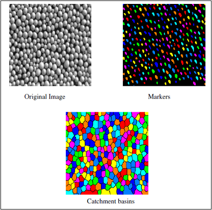
Figure 1: The Catchment Basins command For performance reasons the current implementation ignores (parts of) markers that are at the boundary of the volume.
See also: Add To Label, Reconstruction By Dilation, Reconstruction By Erosion, Fill Label Boundaries.
Input Grayscale Image [required]
The image to be segmented using watershed. Supported types are: 8-bit and 16-bit grayscale image (Uniform Scalar Field), binary (Uniform Label Field with 2 labels) and label (Uniform Label Field) images.Input Label Image [required]
The image of markers that are used as seeds of the watershed process. Supported type is: label image (Uniform Label Field).
Type
This port selects the configuration of this module. The available configurations are:Interpretation
This port specifies whether the input will be interpreted as a 3D volume or a stack of 2D images for processing.
- "3D": the module configuration is set to 3D. The image will be processed as a whole in 3D.
- "XY planes": the module configuration is set to 2D. The image will be processed slice per slice.
Neighborhood
In 3D configuration, this port refers to the type of connectivity considered for processing adjacent voxels:
- 6: voxels with a common face are considered connected
- 18: voxels with at least one common edge are considered connected
- 26: voxels with at least one common vertex are considered connected
Algorithm Mode
This port selects the type of algorithm used to separate the objects. It is one of the following:
repeatable: repeatable but slower
fast: faster but not repeatable because of asynchronous parallel computation.